From Field to Map: Collecting and Analyzing Data with ArcGIS
October 1, 2023 2023-10-03 7:59
From Field to Map: Collecting and Analyzing Data with ArcGIS
In the realm of Geographic Information Systems (GIS), the journey from field data collection to the creation of informative maps has been revolutionized ArcGIS platform. This powerful toolset enables organizations, from environmental agencies to utility companies, to efficiently collect, analyze, and visualize geospatial data. In this article, we’ll explore how ArcGIS facilitates the seamless transition of data from the field to the map, providing valuable insights for decision-makers across various industries.
Related: Simplify Your Data Collection Efforts with ArcGIS Survey123
ArcGIS in Data Collection and Analysis
ArcGIS is a comprehensive GIS platform that encompasses a suite of software, apps, and tools designed to work together seamlessly. One of its key strengths lies in its ability to bridge the gap between data collection in the field and the creation of meaningful maps and spatial analyses.
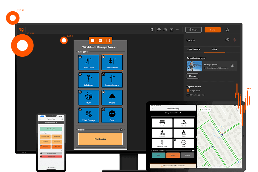
Data Collection with ArcGIS
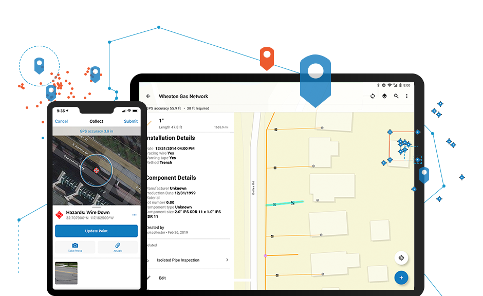
- Mobile Data Collection: ArcGIS offers mobile apps like Collector for ArcGIS and Survey123, which allow field personnel to collect data using smartphones and tablets. Users can capture location-based information, attach photos, and fill out customized forms in real-time, ensuring accurate and up-to-date data.
- Integration with GPS Technology: ArcGIS integrates with Global Positioning System (GPS) devices, enabling precise location data capture. This is invaluable for tasks like asset management, wildlife tracking, and surveying.
- Offline Data Collection: Fieldwork often takes place in remote areas with limited or no internet connectivity. ArcGIS provides the ability to collect data offline, ensuring that critical information is not lost in areas with poor network coverage.
Data Analysis with ArcGIS
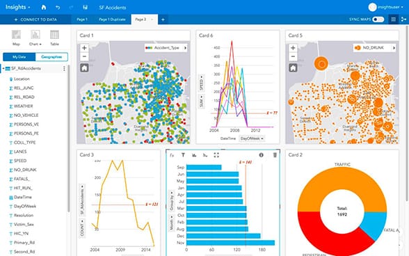
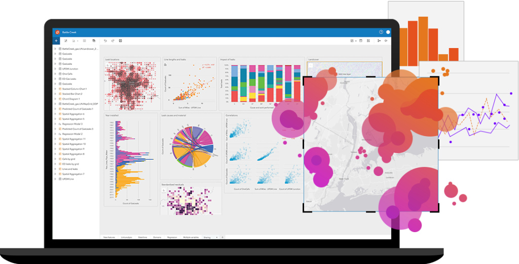
- Spatial Analysis: ArcGIS offers a wide array of spatial analysis tools to extract meaningful insights from collected data. This includes proximity analysis, density mapping, and spatial statistics, which help organizations identify patterns, trends, and correlations.
- Geoprocessing: Geoprocessing tools in ArcGIS allow users to automate complex spatial analyses and data transformations. This streamlines repetitive tasks and ensures consistency in data processing.
- Visualization: Creating compelling maps and visualizations is a hallmark of ArcGIS. It provides tools to generate professional-quality maps, 3D scenes, and dashboards to communicate data effectively to stakeholders.
- Decision Support: ArcGIS’s analytical capabilities empower decision-makers by providing them with a data-driven foundation. Whether it’s optimizing logistics, planning urban development, or managing natural resources, ArcGIS aids in making informed choices.
Benefits of ArcGIS in Data Collection and Analysis
- Efficiency: ArcGIS streamlines data collection and analysis workflows, reducing manual data entry and processing time. This leads to more efficient operations and quicker decision-making.
- Data Quality: The real-time data validation features in ArcGIS apps help maintain data accuracy. Field personnel can receive immediate feedback on data quality, ensuring high-quality data collection.
- Cost Savings: By optimizing fieldwork and resource allocation, organizations can reduce operational costs. ArcGIS helps identify cost-effective solutions and improve overall resource management.
- Informed Decision-Making: The ability to analyze and visualize data in ArcGIS empowers organizations to make informed decisions. This is invaluable in a variety of sectors, from agriculture to emergency management.
ArcGIS has transformed the way organizations collect and analyze geospatial data, ushering in a new era of efficiency, accuracy, and data-driven decision-making. The ability to seamlessly transition data from the field to informative maps and spatial analyses has far-reaching implications across industries. Whether it’s improving environmental conservation efforts, enhancing public infrastructure, or optimizing business operations, ArcGIS is at the forefront of facilitating the journey from field data to actionable insights. As we continue to advance in the realm of geospatial technology, ArcGIS will undoubtedly remain a cornerstone in turning data into knowledge and maps into informed decisions.
Click here to explore ArcGIS products