ArcGIS Pro Review: 15 Reasons to Map Like a Pro
September 11, 2023 2023-09-11 9:26ArcGIS Pro Review: 15 Reasons to Map Like a Pro
Mapping has become an essential tool for various industries, from urban planning and environmental management to business analytics and disaster response. Among the many software options available, ArcGIS Pro stands out as a powerful and versatile solution. ArcGIS Pro offers a wide range of capabilities for mapping and spatial analysis. In this blog post, we will explore 15 reasons why you should consider using ArcGIS Pro to map like a pro.
Related: 3 Things ArcGIS Pro Can Do for You

Why ArcGIS Pro?
Here are 15 reasons why you should consider using ArcGIS Pro to map like a pro:
Modern and intuitive interface
ArcGIS Pro presents a sleek and modern user interface that is easy to navigate. Its ribbon-style menu organizes tools and functions logically, ensuring a smooth learning curve for new users.
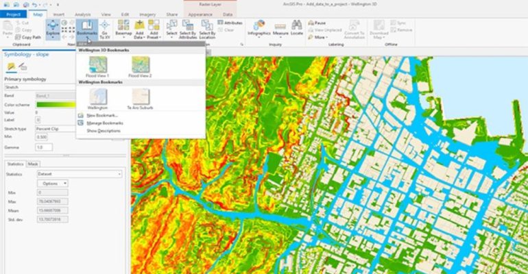
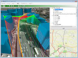
3D mapping and visualization
ArcGIS Pro allows you to create stunning 3D visualizations, enabling you to explore and analyze your data in new ways. With support for advanced rendering techniques and realistic shading, you can bring your maps to life.
Extensive geoprocessing toolbox
ArcGIS Pro offers a comprehensive set of geoprocessing tools, allowing you to perform complex spatial analyses. From basic operations like buffering and overlaying to advanced modeling and machine learning, the toolbox has you covered.
Related: Geocoding and Geoprocessing-Enhancing GIS Analysis with ArcGIS Tools and APIs
Integration with ArcGIS Online
With seamless integration with ArcGIS Online, ArcGIS Pro enables you to leverage a wealth of web-based maps, data, and analysis tools. You can easily access your organization’s content, collaborate with colleagues, and share your work with the wider community.
Related: The Cloud-Based Solution for Geospatial Collaboration
Enhanced data management
ArcGIS Pro provides robust data management capabilities, allowing you to handle large datasets efficiently. You can easily organize, query, and edit your spatial data, ensuring data integrity and accuracy.
Advanced cartographic tools
Creating visually appealing and informative maps is a breeze with ArcGIS Pro. The software offers a wide range of cartographic tools and symbol libraries, enabling you to customize map elements and create professional-looking layouts.
Spatial analysis and modeling
ArcGIS Pro excels in spatial analysis and modeling. Whether you need to perform network analysis, spatial statistics, or site suitability modeling, the software offers an array of powerful tools to support your decision-making processes.
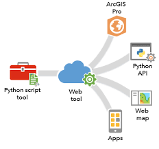
Python scripting and automation
For users with programming skills, ArcGIS Pro provides extensive support for Python scripting. You can automate repetitive tasks, build custom tools, and extend the software’s functionality using the ArcPy library.
Real-time data integration
ArcGIS Pro enables you to incorporate real-time data feeds into your maps and analysis workflows. By visualizing and analyzing live data streams, you can gain valuable insights and make informed decisions in dynamic situations.
Mobile mapping and field data collection
With ArcGIS Pro, you can extend your mapping capabilities to the field. The software seamlessly integrates with mobile devices, enabling you to collect data, update maps, and collaborate with team members in real-time, even in offline environments.
Related: Maximizing Efficiency with ArcGIS Field Apps and Mobile Data Collection
Lidar data processing
ArcGIS Pro provides robust support for processing and analyzing Lidar data. You can derive elevation models, extract features, and conduct terrain analysis with ease, opening new possibilities for applications such as forestry, urban planning, and flood modeling.
Time-series analysis
For analyzing temporal data, ArcGIS Pro offers powerful time-series analysis tools. You can explore trends, detect patterns, and perform change detection over time, empowering you to understand the dynamics of your spatial data.
Enhanced 3D editing
When it comes to editing 3D data, ArcGIS Pro delivers a seamless experience. You can edit features in 3D space, align and adjust geometries, and create accurate 3D models, streamlining your editing workflows.
Related: Five Powerful Capabilities of ArcGIS 3D Analyst
Advanced symbology options
With ArcGIS Pro, you can choose from a wide variety of advanced symbology options to represent your data in visually appealing and informative ways.
Extensive data support
ArcGIS Pro supports a wide range of data formats, including shapefiles, geodatabases, CAD files, raster datasets, and more. You can easily import, visualize, and analyze various types of spatial data.
Click here to buy ArcGIS products.