ArcGIS Python Automation: Streamlining Workflows for GIS Professionals
June 12, 2023 2023-09-06 8:20
ArcGIS Python Automation: Streamlining Workflows for GIS Professionals
In the field of Geographic Information Systems (GIS), efficiency and productivity are key. GIS professionals are constantly seeking ways to streamline their workflows, automate repetitive tasks, and focus more on analysis and decision-making. ArcGIS, a leading platform in the GIS industry, offers a powerful tool for achieving these goals: Python automation. In this article, we will explore how ArcGIS Python automation can revolutionize workflows for GIS professionals.
Introduction to ArcGIS Python Automation
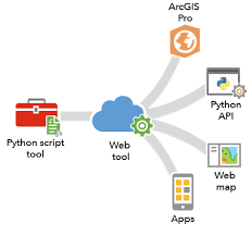
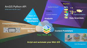
Python is a versatile programming language widely used in various domains, including GIS. ArcGIS provides a comprehensive Python API that allows GIS professionals to automate tasks, create scripts, and develop custom tools tailored to their specific needs. By leveraging the power of Python automation, GIS professionals can save time, improve accuracy, and increase efficiency in their daily workflows.
Related: Automation of Dynamic Data Updates from Google Spreadsheets
How ArcGIS Python automation revolutionizes workflows
Here is how ArcGIS Python automation can revolutionize workflows for GIS professionals:
Automating data management
One of the primary benefits of ArcGIS Python automation is its ability to automate data management tasks. With Python scripts, GIS professionals can perform batch processing, automate data conversions, update attribute tables, and manage spatial datasets efficiently. By automating these repetitive tasks, professionals can focus more on analysis and visualization, enhancing their productivity.
Related: An Easy Solution to Your Data Management Problems

Custom geoprocessing tools
Python automation in ArcGIS enables the creation of custom geoprocessing tools. These tools encapsulate specific GIS workflows and functionalities, allowing GIS professionals to streamline complex processes into a single, user-friendly interface. With custom geoprocessing tools, repetitive or intricate tasks can be simplified and made accessible to users with minimal GIS expertise, enhancing collaboration and usability.
Related: Geocoding and geoprocessing: Enhancing GIS Analysis with ArcGIS Tolls and APIs
Integration with external libraries and APIs
Python’s strength lies in its extensive library ecosystem. ArcGIS Python automation allows GIS professionals to leverage these libraries and integrate them seamlessly into their workflows. Whether it’s data manipulation with Pandas, spatial analysis with GeoPandas, or machine learning with sci-kit-learn, Python automation in ArcGIS empowers professionals to combine GIS capabilities with the broader Python ecosystem for advanced analysis and decision-making.
Task scheduling and batch processing
ArcGIS Python automation provides the ability to schedule tasks and execute batch processes, even in unattended mode. This feature is particularly useful for running routine workflows, data updates, or analyses at specific times or intervals. GIS professionals can set up automated scripts to run overnight or during non-peak hours, ensuring that critical processes are executed without manual intervention.
Collaboration and reproducibility
Python scripts can be easily shared and version-controlled using popular collaboration tools like Git, allowing teams to work together efficiently. Furthermore, Python scripts document the steps involved in a workflow, making it easier to reproduce and share analysis results, ensuring transparency and enabling reproducibility.
Extensibility and customization
This automation offers extensive customization options. GIS professionals can extend the functionality of ArcGIS by developing custom Python add-ins, scripts, or libraries tailored to their specific requirements. This flexibility allows professionals to adapt ArcGIS to their unique workflows and integrate it seamlessly with existing systems and processes.

ArcGIS Python automation is a game-changer for GIS professionals, providing a powerful toolkit to streamline workflows, automate repetitive tasks, and enhance productivity. By leveraging the capabilities of Python, GIS professionals can develop custom tools, integrate external libraries, schedule tasks, and collaborate effectively. With ArcGIS Python automation, the focus can shift from mundane administrative tasks to more strategic analysis and decision-making, ultimately driving efficiency and innovation in the field of GIS.
If you’re looking to embrace this ArcGIS Python automation, click here to explore your options!