Managing, Processing and Analysis of Drone Imagery with Site Scan for ArcGIS
August 16, 2022 2022-08-16 14:37Managing, Processing and Analysis of Drone Imagery with Site Scan for ArcGIS
Managing, Processing and Analysis of Drone Imagery with Site Scan for ArcGIS
Site Scan for ArcGIS is an end-to-end cloud-based drone mapping tool created to revolutionize the gathering, processing, and analysis of visual data. It includes two applications: an iPad app called Site Scan Flight for ArcGIS, which allows drone pilots to capture imagery, and a web app called Site Scan Manager for ArcGIS, which is used to manage drone fleets, securely process imagery in a scalable cloud environment, and quickly share high-quality 2D and 3D imagery products with internal and external users.
With the growing need for imagery with high spatial and spectral resolution – along with temporal resolution, drones fill a critical gap in imagery capture needs. Remote sensing enables users and organizations to capture clear imagery quickly- that is recent enough to accurately define details.
Although remote sensing includes the use of satellites, aircrafts, and drones, using drones significantly reduces the cost of acquisition for imagery and lets you capture high-resolution imagery more quickly and more frequently. Drones also provide a way to capture imagery in a more cost-effective manner.
At Esri Eastern Africa, we provide customers with two drone solutions:
- ArcGIS Drone2Map – It’s a Desktop based drone imagery processing that analyzes and process your data and publish it on ArcGIS Online and Enterprise. The advantage is you can also be able to utilize ArcGIS Drone2Map offline.
- Site Scan for ArcGIS – Its cloud-based, meaning you can log in from any device wherever you are. It allows you to manage drone fleet, visualize, analyze, and process data on web, and then share, collaborate, and publish to ArcGIS Online and Enterprise.
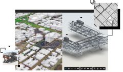
Imagery products you can create with Site Scan for ArcGIS
Here are examples of imagery products you can create with Site Scan for ArcGIS:
- Orthomosaic
It’s a mosaic of orthorectified imagery with minimized distortion from elevation or sensor sources, used as base map for measuring 2D features such as building footprints.
- Elevation Data
A representation of the elevation surface. The value of each pixel corresponds to the elevation above ground. In Site Scan for ArcGIS, you have the option of choosing a DEM or DTM for visualization and analysis.
A DEM (digital elevation model) is a surface that represents the highest point at any x,y location, including man-made or artificial surfaces.
A DTM (digital terrain model) is a surface which represents the bar earth. Man-made features are filtered out.
Elevation layers are used as the base elevation surface for 3D maps, or for calculating slope and aspect for site selection or hydrological applications.
- Point Cloud
A point cloud is a set of points with x, y, and z coordinates placed in a 3D scene. The color of each point is the true color of the object. The resolution of the visualization is relatively coarse compared to orthomosaics or 3D mesh. In Site Scan for ArcGIS, the point cloud is used to measure 3D angles, distances, and heights. Elevation profiles can also be measured from the point cloud in Site Scan.
- 3D Mesh
It’s a continuous 3D surface created from a collection of photos. The 3D mesh is used primarily for visualization purposes such as fly-throughs. In Site Scan for ArcGIS, you can visualize the 3D mesh using virtual reality equipment.
To learn more about managing, processing and analysis of drone imagery with Site Scan for ArcGIS, watch the webinar https://www.youtube.com/watch?v=K8ALOT4a5wM&t=134s
You can also visit our https://ea-store.esri.com/en-ke/store/overview online store to purchase ArcGIS products.