Evaluating Urban Development Plans with ArcGIS GeoPlanner
August 2, 2022 2023-02-17 11:39Evaluating Urban Development Plans with ArcGIS GeoPlanner

Cities are understood to provide a variety of purposes in all societies. They serve as a breeding ground for poverty, inequality, environmental dangers, and communicable diseases while also being at the center of technical advancement and economic prosperity in many countries. Numerous issues arise when big populations gather in cities. Today, it’s estimated that almost 55% of the World’s population lives in urban areas, and this trend is expected to rise within the coming years. The speed at which the urban population is growing will lead to severe challenges.
How does ArcGIS GeoPlanner come into play?
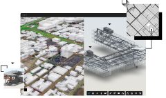
ArcGIS GeoPlanner is a web-based app for informed evidence and performance-based planning and design. It provides a design framework for professionals to leverage geographic information and offers a collaborative set of tools for use in scenario planning. It’s a Geo design tool that helps in creating, analyzing, and reporting planning alternatives.
Due to limited land resources, development demands, and intricate planning procedures, planning authorities have substantial obstacles in protecting key places from rapid growth and development. ArcGIS GeoPlanner for geodesign and scenario planning constantly monitors the environmental impact of new and current designs. It helps in communicating design purpose while addressing environmental constraints through geographical context and visual storytelling.
It can be a useful tool for professional engaged in but not limited to:
- Urban planning
- Forestry management
- Conservation planning
- Green infrastructure planning
This application enables you to:
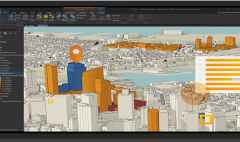
- Explore existing conditions
- Design and sketch with ease
- Evaluate impacts and compare alternatives
- Leverage on the built-in metrics and dashboards to help you track, evaluate and report on the impact of your design
- Use iterative scenario planning with ease
This allows you to inform your design with powerful analytics.
This web-based app is integrated across ArcGIS platform. Projects in ArcGIS GeoPlanner can also be used in other applications across the ArcGIS Platform. Scenarios created on ArcGIS GeoPlanner can be used in ArcGIS Pro to conduct further analysis on the data used, creating master plans in City Engine, and on ArcGIS Hub to gather feedback and collect input from communities, stakeholders, and other decision makers within projects. The result of the projects created can be visualized on the Dashboards to better understand the KPIs and how they are met within the different scenarios.
Licensing Model and Setting up ArcGIS GeoPlanner
ArcGIS GeoPlanner is a premium application that is hosted within ArcGIS Online and therefore, it requires you to have an organizational account and a named user license. You cannot use a public or a personal use account for GeoPlanner.
Click here https://youtu.be/WpRrgDQW0wM to learn how you can evaluate and share a project design in ArcGIS GeoPlanner.
You can also purchase ArcGIS GeoPlanner and other ArcGIS products from our online store.


Comment (1)
Gezahagn Negash Seboka
Thanks for sharing!