ArcGIS Geostatistical Analyst Extension
September 19, 2022 2022-09-19 9:07
ArcGIS Geostatistical Analyst Extension
ArcGIS Geostatistical Analyst lets you make accurate predictions about an area based on sample data points. You can explore spatial correlations and patterns in your data, build interpolation models based on those patterns, compare alternate scenarios, cross-validate your results, and then use the best models as a basis for your decisions. These tools help you explore spatial data, assess risk, and accurately predict values within your study area, even in places where you’re missing reliable sample data.
It provides the capability for surface modelling using deterministic and geostatistical methods. The tools it provides are fully integrated with the GIS modelling environments and allow GIS professionals to generate interpolation models and assess their quality before using them in any further analysis. The tools provided in the extension are grouped into three categories:
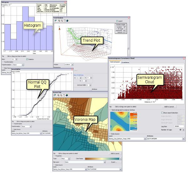
- Geostatistical analyst toolbar: It gives access to a series of Exploratory Spatial Data Analysis (ESDA) graphs.
- Geostatistical Wizard; Its accessed through toolbar and leads analysts through the process of creating and evaluating an interpolation model.
- Geoprocessing tools (Geostatistical analyst Tool): Designed to work with the outputs of the models and extend the capabilities of the Geostatistical wizard.
The Geostatistical Analyst contains unique tools that can be used to address a wide range of different application areas. These tools are Exploratory spatial data analysis, Semi variogram modelling and ordinary kriging, Surface prediction and error modelling, Threshold mapping, model validation and diagnostics, surface prediction using cokriging.
Sectors that can utilize Geostatistical analyst extension include:
- Agriculture-predict resource yields at various sites (determining soil fertility of large acre of farm, determining soil hydraulic properties of a large farm to effectively manage irrigation water management)
- Disaster risk department- used to model disaster risk like environmental pollution exposure in urban areas.
- Commercial-Plan business growth.
- Urban Planning-Urban expansion.
- Population prediction.
- Transport-Forecasting traffic.
To purchase our ArcGIS products online, click https://ea-store.esri.com/en-ke/store/overview
You can also share your story of how Geostatistical Analyst has helped you in the comment section below!