What’s New for CAD and BIM in the 2025 Release of ArcGIS Pro
August 11, 2025 2025-08-11 13:33What’s New for CAD and BIM in the 2025 Release of ArcGIS Pro
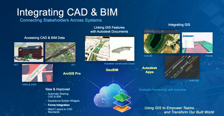
ArcGIS Pro has long been a go-to tool for GIS teams working with data created in a wide range of design and engineering software. Whether it’s models of buildings, transport infrastructure, utilities, industrial facilities, or other assets, this information becomes valuable spatial data when integrated into GIS workflows. ArcGIS Pro supports CAD and BIM data from multiple formats, including Autodesk® Civil 3D®, AutoCAD® (.dwg), Revit® (.rvt), Industry Foundation Classes (.ifc), and more.
By combining these data sources into maps and scenes, GIS professionals can place design content in context and share it with designers, project managers, and other stakeholders through web layers in ArcGIS Online or ArcGIS Enterprise.
The May 2025 release, ArcGIS Pro 3.5, introduces enhancements designed to cut down on repetitive manual tasks and make it easier to both use and share project information. These updates benefit professionals in architecture, engineering, construction, operations (AECO), transportation, and beyond.
Key Updates at a Glance
The latest CAD and BIM integration features in ArcGIS Pro 3.5 streamline authoring tasks and improve collaboration between GIS and design teams. Highlights include:
- Direct scene layer creation from 3D CAD content for faster sharing workflows.
- Support for reading and exporting CAD hatch objects, reducing manual symbology work.
- Ability to set BIM Cloud Connections as favorites for quicker access to important projects.
Direct Scene Layer Creation from 3D CAD
Previously, sharing 3D CAD content to ArcGIS Online or ArcGIS Enterprise required several intermediate steps. With ArcGIS Pro 3.5, you can now create scene layers directly from 3D CAD drawings, making the process faster and more efficient.
This means engineering data for roads, railways, and other infrastructure can be seamlessly integrated into web scenes and digital twins, improving project coordination for stakeholders such as asset and project managers.
Direct-Read and Export of CAD Hatches
Hatch objects are common in CAD drawings, often used to indicate areas like medians, bike lanes, or crosswalks. Converting these hatches into usable GIS elements has traditionally been a time-consuming task.
ArcGIS Pro 3.5 now supports direct reading and exporting of hatches, allowing you to preserve design intent without extensive manual cleanup. This enhancement streamlines the process of incorporating CAD symbology into GIS maps and exporting GIS features back into CAD drawings for use by design teams.
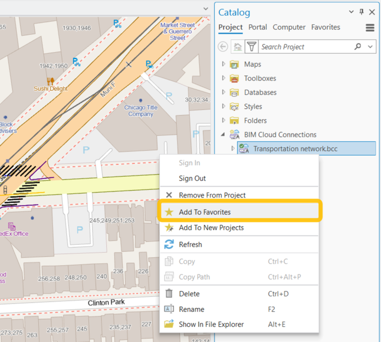
Mark BIM Cloud Connections as Favorites
BIM Cloud Connections in ArcGIS Pro provide access to design files stored in online repositories such as Autodesk Construction Cloud®. In the past, tracking these connections manually could be cumbersome, especially for large projects with multiple repositories.
With ArcGIS Pro 3.5, you can now mark frequently used BIM Cloud Connections as favorites. This simple addition keeps important design and engineering files at your fingertips, making it easier to combine BIM, CAD, and other spatial data in your projects.
ArcGIS Pro continues to evolve with deeper CAD and BIM integration, making it easier for GIS teams to bring design and engineering data into spatial analysis, visualization, and sharing workflows. Future releases will build on these capabilities, offering even more ways to connect GIS with the tools used by design professionals.
To learn more about ArcGIS and how to purchase it online, visit our online store: https://ea-store.esri.com/en-ke/store/overview