Welcome to the World of GIS Careers
September 2, 2026 2026-09-02 7:30
Welcome to the World of GIS Careers
Geographic Information Systems (GIS) is much more than creating maps. It is a powerful technology that helps people understand the world around them, uncover patterns, solve complex problems, and make better decisions.
From planning smarter cities and managing natural resources to improving healthcare, responding to emergencies, and supporting business growth, GIS is used across countless industries. For students exploring future career opportunities, professionals considering a career change, or anyone interested in technology and data, the world of GIS offers an exciting and rapidly expanding range of possibilities.
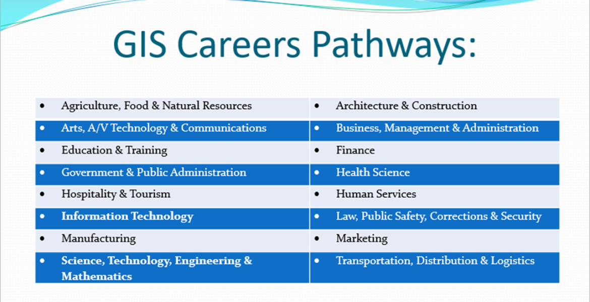
16 Career Clusters, Endless Opportunities
One of the most exciting things about GIS is its versatility. GIS skills can be applied across a wide range of career paths, opening doors to opportunities in both traditional and emerging industries.
Esri highlights 16 major career clusters where GIS can play an important role. These include:
- Agriculture, Food & Natural Resources
- Health Science
- Information Technology
- Government & Public Administration
- Science, Technology, Engineering & Mathematics (STEM)
- Law, Public Safety, Corrections & Security
- Business Management and Administration
- Transportation, Distribution and Logistics
- Architecture and Construction
- Education and Training
…and many more.
Each career pathway presents unique opportunities to apply geographic knowledge and spatial thinking. In agriculture, GIS can help farmers monitor crops, analyze soil conditions, and improve productivity. In public safety, professionals can use location data to analyze crime patterns and plan emergency responses. Environmental scientists can monitor deforestation, wildlife habitats, and the impact of climate change.
The possibilities are vast because almost every challenge has a location component.
From GIS to Location Analysis
In some higher education institutions, GIS is increasingly being described as Location Analysis. This term helps highlight the broader value of GIS and reflects what GIS professionals do every day. Location analysis is about understanding where things happen, why they happen in specific places, how different locations are connected, and what those patterns mean for people, businesses, communities, and the environment.
GIS professionals work with different types of information, including:
- Location – Where something is situated.
- Physical dimensions – The size, shape, and spatial extent of an object or area.
- Attributes – Additional information about an object, such as its type, value, condition, or characteristics.
By bringing these different types of information together, GIS helps transform raw data into meaningful insights.
For example, GIS can be used to identify areas affected by deforestation, determine the best location for new infrastructure, understand patterns in disease outbreaks, or help businesses identify potential customers and new market opportunities.
A Career Built Around Solving Real-World Problems
A career in GIS is not limited to working behind a computer and producing maps. GIS professionals are problem-solvers, analysts, researchers, developers, planners, and decision-makers. Depending on their interests and skills, a GIS professional may work as a:
- GIS Analyst
- GIS Technician
- Cartographer
- Spatial Data Scientist
- Remote Sensing Specialist
- Urban and Regional Planner
- Environmental Analyst
- GIS Developer
- Geospatial Intelligence Analyst
- Location Intelligence Specialist
As organizations continue to collect more data, the ability to understand and analyze the where behind that data is becoming increasingly valuable.
GIS and the Rise of Artificial Intelligence
The future of GIS is becoming even more dynamic with the rapid growth of Artificial Intelligence (AI). AI and GIS are increasingly working together to help organizations process large amounts of geographic data faster and uncover insights that may otherwise be difficult to identify.
AI is enhancing GIS in several ways, including:
- Automated satellite and imagery analysis – AI can help identify objects, land cover, and changes across large geographic areas.
- Predictive modeling – Organizations can use spatial data and AI to better understand potential future patterns, such as urban growth or changes in land use.
- Real-time optimization – GIS and AI can support smarter logistics, transportation, and delivery operations.
- Pattern recognition – AI can help identify relationships and trends within large and complex spatial datasets.
This convergence of AI and GIS is creating new opportunities for innovation and expanding the skills needed in the geospatial profession.
The Future Is Spatial
The demand for professionals who can understand and work with location-based data continues to grow. As industries become more data-driven, organizations need people who can turn information into insights and insights into action. Whether your passion lies in technology, environmental conservation, business, healthcare, urban planning, agriculture, or public safety, there is likely a place for GIS in your chosen field.
A career in GIS offers the opportunity to work with cutting-edge technology while addressing real-world challenges. It combines geography, data, technology, and analytical thinking to help us better understand our world. So, if you are exploring your next career move or thinking about the skills that will shape the future of work, this may be the perfect time to step into the exciting world of GIS.
The future is increasingly connected, data-driven, and spatial. The question is: where will GIS take you?