
How to Capture Different Feature Types in a Single ArcGIS Survey123 Workflow
August 21, 2026 2026-08-21 13:12
How to Capture Different Feature Types in a Single ArcGIS Survey123 Workflow
Field teams rarely collect just one kind of geographic information. A surveyor might need to mark individual trees as points, trace hedgerows as lines, and outline areas of vegetation as polygons, all during the same site visit. Creating separate surveys for each type of feature can quickly make data collection more complicated than it needs to be.
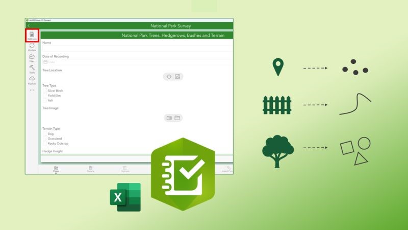
With ArcGIS Survey123, there is a way to bring these different feature types together within a single field workflow. The trick is to structure the survey so that the different geometries are captured through repeats in Survey123 Connect.
Why multiple geometry types can be challenging
ArcGIS feature layers are designed around a single geometry type. A point feature layer, for example, cannot simultaneously store line and polygon features. That can appear to create a problem if your field team needs to collect several types of spatial features as part of one inspection or site survey.
Rather than trying to force different geometries into one feature layer, you can use Survey123’s relationship structure to separate the individual feature records while keeping them associated with the main survey. This approach is particularly useful when the different features belong to the same overall survey, site, project, or inspection.
The role of Survey123 Connect
Survey123 can be configured through the web designer, but more advanced survey designs can be created using Survey123 Connect. Connect works with XLSForm and provides additional control over the survey’s structure and behaviour. A practical workflow is to create the basic survey first and then move into Connect when you need more sophisticated functionality.
One of the most useful features for this type of workflow is the repeat.
Using repeats to separate feature records
A repeat allows respondents to submit the same group of questions multiple times. For example, imagine an environmental survey where the main record represents a site inspection. Within that inspection, the fieldworker might need to record:
- Individual trees
- Hedgerows
- Vegetated areas
- Different terrain zones
Each of these can be represented by its own repeat. The repeat can contain the relevant attribute fields alongside its geometry question. A respondent can then add as many records as are required while completing the survey. The important part is how Survey123 stores those records.
Rather than attempting to put every geometry into the main feature layer, the repeat records are stored separately and associated with the parent survey record.
A practical environmental survey structure
Consider a survey for managing a large nature reserve. The main survey could capture information about the visit:
Site inspection
- Survey date
- Surveyor
- Site ID
- General notes
The survey could then contain separate repeats for different observations:
Tree observations
- Tree species
- Condition
- Location
Hedgerow observations
- Hedgerow type
- Condition
- Length or location
Vegetation areas
- Vegetation type
- Condition
- Area
Each repeat can contain the appropriate geometry question. This means the fieldworker has one survey experience, while the resulting GIS data remains organised according to geometry type.
How the resulting data is organised
Once records have been submitted, the structure becomes more apparent. The main survey record acts as the parent. The repeat records sit beneath it in related tables or layers, depending on how the survey is configured. Survey123 uses identifiers to establish these relationships. A parent survey record has a GlobalID, while records created within repeats can reference that parent through the corresponding relationship field.
This gives you a useful balance:
One field workflow → multiple feature datasets → linked records
The geometry remains appropriate for each individual feature type without losing the relationship between those features and the original survey.
Think about the parent record before building the survey
There is an important design consideration here. If the main survey does not contain a geometry question, Survey123 still needs a way to establish the spatial context of the overall submission. Depending on the configuration, this can result in a point feature being created for the parent record.
Before publishing your survey, decide what the parent record represents geographically. For example, the parent could represent:
- A national park
- A school campus
- A construction site
- A utility inspection
- A land parcel
- A maintenance visit
You could capture an overall boundary as the main survey geometry, or use an identifier such as a site or asset ID to associate the survey with an existing GIS feature.
This decision can make a significant difference when the data is later analysed or visualised.
When this approach is useful
A multi-geometry Survey123 design can be particularly useful for field workflows such as:
Environmental surveys
Capture trees, invasive species, habitat areas and linear features during one visit.
Asset inspections
Record the location of individual assets alongside areas or linear infrastructure associated with the inspection.
Education and estates
Map buildings, fences, sports pitches, paths and other features around a campus.
Land management
Collect different types of vegetation, boundaries and land-use features during the same survey.
Site assessments
Combine observations about individual objects with mapped areas and linear features.
Designing the survey around the data—not just the form
The biggest advantage of this approach is that it encourages you to think about the relationship between the field workflow and the resulting GIS data. Instead of asking, “How can I make one feature layer contain every geometry?”, consider:
What does one survey represent, and what individual features need to be associated with it?
Once that relationship is clear, repeats provide a practical way to let fieldworkers collect multiple feature types without having to switch between several separate surveys. The result is a more streamlined collection process while retaining a structured GIS data model behind the scenes.
Key takeaway
Survey123 does not need to be limited to a single type of spatial observation simply because an individual feature layer supports only one geometry type. By using Survey123 Connect and repeats, you can build a single field workflow that captures points, lines and polygons as related records.
The most important step is to design the underlying relationship carefully: determine what the main survey represents, decide which observations belong in repeats, and establish how those records should be linked. Once that structure is in place, a complex multi-feature field survey can become much easier for the people collecting the data – and much easier to manage once the data reaches your GIS.
Stay up to date with the latest product news and updates by subscribing to our ArcHabari Weekly Newsletter.