Harnessing the Power of Remote Sensing with ArcGIS
June 8, 2023 2023-06-08 9:08Harnessing the Power of Remote Sensing with ArcGIS

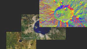
Remote sensing, the science of acquiring information about the Earth’s surface without direct physical contact, has revolutionized our understanding of the planet. It allows us to gather valuable data from a distance, using sensors mounted on aircraft, satellites, or even drones. This technology has found its applications in various fields such as environmental monitoring, urban planning, agriculture, and disaster management. When combined with advanced Geographic Information System (GIS) tools like ArcGIS, remote sensing becomes a powerful tool for analysis and decision-making.
ArcGIS provides a comprehensive suite of tools for managing, analyzing, and visualizing geographic data. With its integrated remote sensing capabilities, ArcGIS enables users to process and interpret remotely sensed imagery to extract valuable information. Here, we explore some advanced techniques in remote sensing that can be harnessed using ArcGIS.
Related: Imagery Analysis in ArcGIS Pro
Advanced techniques in ArcGIS
Here are some advanced techniques in remote sensing that can be harnessed using ArcGIS:
Image classification
Image classification is the process of categorizing pixels in a remotely sensed image into different classes based on their spectral properties. This technique allows you to map land cover types, monitor vegetation health, detect changes over time, and identify various features on the Earth’s surface. ArcGIS provides advanced classification algorithms, such as maximum likelihood, support vector machines, and random trees, which can be applied to multispectral or hyperspectral imagery. These algorithms utilize spectral signatures and statistical methods to assign pixels to specific classes, creating accurate and detailed land cover maps.
Change detection
Change detection techniques enable us to identify and quantify the differences between multiple images acquired at different times. It’s particularly useful for monitoring land use changes, urban growth, deforestation, and natural disasters. ArcGIS offers powerful change detection tools that leverage pixel-based or object-based approaches. By comparing spectral, spatial, or temporal characteristics of the images, these tools highlight areas of change, allowing users to understand the dynamics of the landscape and make informed decisions.
Terrain analysis
Remote sensing data can be used to derive valuable terrain information, such as digital elevation models (DEMs), slope, aspect, and surface roughness. ArcGIS provides robust tools for processing and analyzing elevation data obtained from remote sensing sources like Light Detection and Ranging (LiDAR) or stereo imagery. These tools enable users to perform terrain classification, identify potential landslide zones, assess drainage patterns, and model hydrological processes. By combining remote sensing data with GIS-based terrain analysis, researchers and planners can gain valuable insights into the Earth’s topography and better understand the interactions between terrain and various phenomena.
Related: Raster Analysis Using ArcGIS Pro
Object-based image analysis (OBIA)
Object-based image analysis is an approach that groups pixels into meaningful objects based on their spectral, spatial, and contextual characteristics. It allows for more accurate and detailed extraction of information from remotely sensed imagery. ArcGIS incorporates OBIA tools that enable users to segment images into objects and extract relevant features. This technique is particularly beneficial for urban mapping, precision agriculture, and natural resource management. By considering the spatial relationships and contextual information of objects, analysts can extract valuable information such as building footprints, tree canopies, or agricultural parcels.
Hyperspectral analysis
Hyperspectral imaging involves acquiring imagery across a wide range of narrow and contiguous spectral bands. This technique provides a more detailed spectral signature of the Earth’s surface, allowing for the identification and characterization of materials with high precision. ArcGIS supports hyperspectral data analysis, enabling users to explore and analyze hyperspectral imagery. With advanced techniques like spectral unmixing, endmember extraction, and feature extraction, researchers can identify specific materials, detect subtle changes, and assess environmental conditions more accurately.
In conclusion, the integration of remote sensing techniques with ArcGIS unlocks a world of possibilities for understanding our planet and making informed decisions. With ArcGIS’s advanced tools and capabilities, we can delve into the intricate details of remotely sensed imagery, extract valuable information, and gain deeper insights into our environment. Whether it’s classifying land cover, detecting changes, analyzing terrain, performing object-based analysis, or exploring hyperspectral data, ArcGIS empowers GIS professionals to harness the power of remote sensing to its fullest potential.


Comments (2)
Namakula Martha
I am so grateful to meet such good information. Waiting on learning more
Rachael Mutuli
Thank you so much for your kind words and for taking the time to read our blog! Stay tuned for more engaging and insightful articles in the future.