GeoAI Is Powering a Smarter Future for Utility Infrastructure
September 30, 2025 2025-10-06 8:03GeoAI Is Powering a Smarter Future for Utility Infrastructure

The ArcGIS platform is transforming how utilities manage infrastructure, offering a real-world, detailed view of assets that supports smarter decisions, greater efficiency, and task automation. Designed as an enterprise GIS solution, ArcGIS helps utilities across electric, gas, water, and telecommunications sectors manage assets and workflows across entire service areas. Organizations use ArcGIS to build scalable digital models of their networks, streamline operations, and improve collaboration.
From maintaining accurate asset inventories to documenting how those assets are connected, ArcGIS lays the foundation for better decision-making both in the field and at the office. Because it’s built on open IT standards, ArcGIS also integrates seamlessly with other business systems, bringing location intelligence into core utility operations. Now, with the rapid advancement of artificial intelligence (AI), utilities are entering a new era. The combination of GIS and AI (GeoAI), is unlocking faster, smarter, and more predictive ways to manage infrastructure.
What Is GeoAI?
GeoAI (Geospatial Artificial Intelligence) blends spatial data, geospatial technology, and AI to provide deeper insights into complex, real-world environments. Within the Esri ecosystem, GeoAI enables automation, pattern detection, and scenario modeling that drive intelligent, data-driven decisions.
Across industries, organizations are already using GeoAI for intelligent feature extraction, predictive modeling, and workflow automation. For utilities, the impact is especially significant. GeoAI can:
- Automate inspections using imagery and sensor data
- Predict failures, outages, and maintenance needs
- Monitor and manage vegetation risk through advanced image analysis
- Improve data accuracy by identifying inconsistencies
By embedding GeoAI into GIS workflows, utilities can shift from reactive to proactive operations, saving time, reducing costs, and improving reliability.
How GeoAI Enhances Utility Operations
GeoAI is driving innovation across the utility sector by automating tasks and enabling predictive capabilities that improve operational performance. Here are four key areas where GeoAI is making a difference:
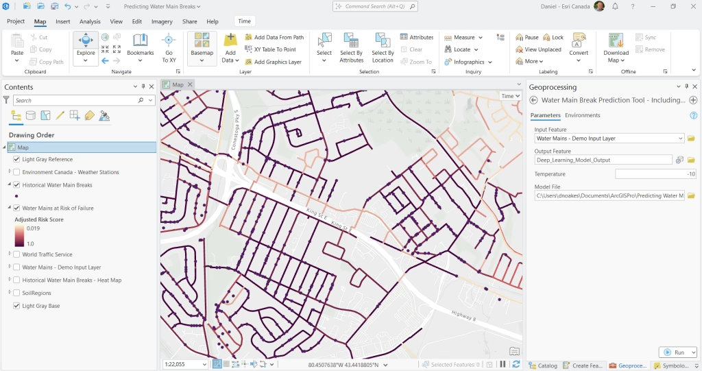
1. Predictive Maintenance and Outage Management
Using deep learning tools in ArcGIS Pro, ArcGIS Notebooks, ArcGIS Image Analyst, and web apps, utilities can analyze asset conditions, environmental factors, and sensor data to detect early signs of failure. For example, GeoAI can identify aging or high-risk water mains before they fail, helping reduce service interruptions, speed up repairs, and lower costs.
2. Smarter Vegetation Management
Vegetation near utility lines is a constant risk. With GeoAI, utilities can analyze aerial imagery, LiDAR, and deep learning models to detect vegetation encroachment before it becomes a problem. GeoAI not only flags risks but also predicts vegetation growth, helping teams plan trimming efforts proactively, prevent outages, and optimize maintenance schedules.
Example: ArcGIS Dashboards, enhanced with AI, are used to display vegetation risks by severity, allowing for better planning and prioritization.
3. Automated Asset Detection and Mapping
Manually locating and cataloging assets across vast territories is time-consuming. GeoAI simplifies this with computer vision and deep learning that automatically recognize and classify infrastructure from imagery like LiDAR. The result? Faster asset mapping, improved accuracy, and up-to-date records that support better decision-making and reduced manual effort.
Interactive Example: Utilities use ArcGIS StoryMaps to visualize how LiDAR is transforming asset mapping and planning.
4. Enhanced Field Operations
Field crews benefit directly from GeoAI-powered tools like ArcGIS Survey123 (beta), which includes AI-assisted image recognition. This smart assistant identifies asset types and conditions from photos, automatically populating data forms, speeding up data collection while minimizing errors. This means faster reporting, consistent data, and more efficient field operations.
The Value of GeoAI for Utilities
Integrating GeoAI into the ArcGIS system is more than a tech upgrade, it’s a strategic shift that improves how utilities plan, operate, and respond. Benefits include:
- Predictive insights from large, complex datasets
- Smarter field data collection and automated asset recognition
- Improved situational awareness through integrated data sources
- Workflow automation that frees up resources for critical tasks
The ArcGIS system combines machine learning, deep learning, and spatial analytics with AI-enhanced field tools to help utilities gain real-time insights and make faster, location-aware decisions.
Looking Ahead
GeoAI is reshaping how utilities operate, moving them from reactive processes to proactive strategies. As the technology evolves, it will continue to drive improvements in safety, reliability, and sustainability.
To learn more: https://www.esriea.com/water-utilities/ or https://www.esriea.com/energy-utilities/