How Remote Sensing Is Revolutionizing Geospatial Decision-Making
October 6, 2025 2025-10-13 6:53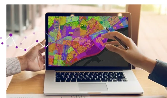
How Remote Sensing Is Revolutionizing Geospatial Decision-Making
Remote sensing is redefining how organizations understand, monitor and manage the world around them. By capturing imagery and data from satellites, aircraft and drones, then applying AI to extract insight; businesses and governments can now respond to real-world changes with speed, accuracy and confidence.
Whether you’re tracking land use, monitoring infrastructure, or responding to disasters, remote sensing delivers timely, location-based intelligence that drives smarter decisions across industries like agriculture, mining, urban planning and emergency management. It’s not just about collecting data from a distance, it’s about transforming that data into meaningful, actionable insight.
Why Remote Sensing Matters Now
The ability to observe the Earth’s surface without direct contact unlocks new levels of situational awareness. Satellite and aerial imagery give detailed views of urban expansion, vegetation changes or asset conditions. Drones deliver real-time updates on infrastructure, environmental impacts or disaster zones. Aerial imagery, captured via crewed aircraft, offers a balance of scale and resolution, ideal for local councils, utilities and emergency responders who need accurate, up-to-date views over large areas. This explosion of geospatial intelligence empowers organizations to act faster, plan better and stay ahead in a data-driven world.
Real-world applications across industries
The applications of remote sensing technologies are vast and varied, significantly impacting multiple industries.
Agriculture
In agriculture, these technologies are used to monitor crop health, optimize irrigation, and predict yields. By leveraging multispectral imaging, farmers can reduce water usage, optimize fertilizing regimes, and improve yield forecasts. This leads to more sustainable and profitable practices.
Urban planning and development
Urban planning and development benefit immensely from remote sensing. Sentinel-2 imagery, which provides medium-resolution satellite data, enables planners to track land-use changes, plan infrastructure, and ensure zoning compliance. This results in more sustainable and informed city planning, crucial for managing urban growth while maintaining environmental balance.
Mining
Remote sensing has revolutionized mining operations, improving efficiency, safety, and environmental management. Satellite imagery helps identify potential mineral deposits and supports detailed geological mapping, accelerating exploration and reducing the need for extensive ground surveys.
High-resolution aerial data enables accurate site planning, including access routes and infrastructure layouts, while drones provide real-time monitoring of stockpile volumes, excavation progress, and equipment movement to optimize operations.
These technologies also play a key role in monitoring vegetation loss, water quality, and land rehabilitation to ensure environmental compliance. By reducing risks and enabling remote inspection of hazardous areas, such as tailings dams or unstable slopes, remote sensing enhances safety and prevents accidents.
Emergency management
Remote sensing technologies provide critical situational awareness during disasters, supporting rapid response, recovery, and preparedness. Drones and satellites deliver real-time visuals of flood zones, wildfires, or earthquake damage, helping responders assess conditions and prioritize resources effectively.
High-resolution imagery supports detailed damage assessments, guiding recovery efforts and resource allocation. Thermal imaging from drones can assist in search and rescue operations, locating survivors in hard-to-reach areas. Remote sensing also aids in disaster preparedness by mapping vulnerable regions, such as floodplains or fire-prone zones, to inform risk mitigation strategies.
By providing a shared operational picture, these technologies improve coordination among agencies and support faster, more effective emergency response.
Leveraging AI for enhanced data analysis
Artificial Intelligence (AI) plays a pivotal role in enhancing the capabilities of remote sensing technologies. AI-driven analytics can process large datasets quickly, providing actionable insights with minimal manual input. Automated image classification identifies patterns such as crop stress, unstable ground, or infrastructure damaged without the need for manual analysis.
Predictive analytics, powered by machine learning algorithms, can forecast infrastructure failures or environmental risks. For example, mining operations can predict potential slope collapses, while emergency managers can model flood progression or wildfire spread.
This enables proactive measures, improves safety, and reduces downtime or critical system outages. By automating image analytics workflows like data processing and reporting, AI frees up time for teams to focus on higher-value tasks.
Integrating satellite imagery and drone data seamlessly
Integrating remote sensing technologies into organizational workflows doesn’t have to be a daunting task. Scalable tools can grow with an organization’s needs, whether it’s managing small projects or overseeing complex infrastructure.
Free and open satellite imagery, such as Sentinel-2 or Landsat data, provides medium-resolution coverage for monitoring environmental changes and urban development at a regional scale. For higher-resolution needs, commercial satellite or aerial imagery can offer the fine detail required for localized decision-making, such as assessing a single mine site or disaster area.
Drone data can provide real-time views of pipelines, powerlines, and construction sites, facilitating asset management. While 3D models created from drone and LiDAR data can offer 3D digital twins of infrastructure, enabling planners to visualize and optimize development projects more effectively.
Overcoming data overload with smart tools
The sheer volume of geospatial data generated by modern remote sensing can be overwhelming. Platforms such as Esri’s ArcGIS provide smart tools to filter, process, and visualize only the most relevant information.
- Custom filters focus on specific regions or timeframes, removing irrelevant data.
- Real-time monitoring through satellite feeds and drone networks allows organizations to respond to events as they unfold.
- Inactive maps and dashboards make complex datasets easier to understand and communicate.
Platforms like Esri’s ArcGIS provide advanced LiDAR analytics, imagery analytics, and multi-spectral remote sensing tools, empowering organizations to streamline operations and adapt to changing demands with accuracy and efficiency.
Future-proofing operations with advanced remote sensing
Remote sensing continues to evolve, delivering cutting-edge analytical tools and capabilities. High-resolution aerial or satellite imagery enables detailed analysis of land use, water levels, or infrastructure conditions, while AI-powered forecasting can predict challenges such as crop yield fluctuations, environmental stress, or equipment failures.
3D modelling and digital twins provide interactive representations of entire cities, mine sites, or disaster zones. This empowers planners and operators to simulate scenarios, assess risks, and plan maintenance or expansions with precision.
By staying ahead of these advancements, organizations can future-proof their operations, ensuring they remain competitive and resilient in a rapidly changing world.
Transforming decision-making across industries
By integrating cutting-edge remote sensing technologies, organizations can revolutionize how they approach geospatial decision-making. From improving agricultural sustainability to optimizing mining operations and enabling faster, safer emergency responses, these tools provide actionable insights that drive both operational efficiency and environmental stewardship.
The result is a smarter, more proactive approach to managing the world’s most pressing challenges and a path toward sustainable, informed growth across industries.