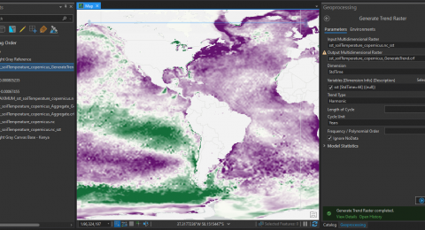
How to Perform Multidimensional raster analysis in ArcGIS Pro
Multidimensional data represents data captured at multiple times or multiple depths …

An Easy Solution to Your Data Management Problems
Today, almost all C-suite executives view data management as an essential …

5 Simple ways to learn GIS technology
If you’re seeking an exciting career in your higher learning, a …

What Can I Do with a GIS Degree?
Are you wondering whether it’s worth getting a degree in GIS? …

Expanding Education and Career Opportunities
By striking a balance between technical skills and conceptual understanding, GIS …
Benefits of GIS (Geographic Information System)nbsp;
Whether maps are used to map your geographic area, visualize boundaries, …

Addressing Supply Chain Issues with GIS: Solving Logistics Challenges
GIS mapping ties many different data sources together and allows experts …

Simplified Learning with ArcGIS Story Maps
With ArcGIS Story Maps, you can combine texts, photos, and videos …

Locate your customer!
GIS helps you to gather economic, psychographic, and demographic data on …

Integrating GIS with Healthcare Solutions
From the likes of Koch T. the author to Cartographies of …

3 Things ArcGIS Drone2Map can do for you
Today, the traditional field data gathering, and imagery-production workflows are being …

Esri Eastern Africa Opens New Offices in Uganda
Esri Eastern Africa, the region’s leading provider of geospatial solutions is …