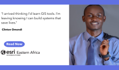
Somewhere with Ampumuza Desire
June 12, 2026 2026-06-16 13:35
Somewhere with Ampumuza Desire
When you first meet Ampumuza, what stands out isn’t just her academic path- though impressive. A graduate with a Bachelor of Arts in Education (Geography major), now pursuing a Master’s degree in Geographical Information Systems (GIS) and Remote Sensing at Kyambogo University.
Ampumuza is skilled in spatial data analysis, mapping and geospatial technologies, with experience analysing environmental challenges. She has built her foundation around understanding the world through space, patterns and relationships— a shift from simply working with maps to truly thinking spatially.
In a recent Q&A interview, she shared what it was like to be an intern at Esri Eastern Africa.
Learning to Think Spatially
Maps, for most people are static, informational background layers. But in GIS, maps are alive. They tell stories, reveal patterns and support decisions. For Ampumuza, this distinction became clear early in her internship experience and central to her learning.
Like many interns, she did not arrive with everything figured out. What stood out was her curiosity. GIS, she quickly learned, is not just about tools—it is about thinking differently. Moving from structured tasks to independent analysis required more than technical skill. It meant interpreting complex environmental data, identifying patterns and making decisions about what mattered—and what did not.
Inside the GIS Internship Experience
Ampumuza sums up her experience at Esri Eastern Africa as transformative.
“The opportunity to collaborate with fellow interns and professionals from different countries across East Africa – Uganda, Kenya and Tanzania, allowed me to exchange ideas, learn new perspectives, and understand how GIS is applied to solve different regional challenges”, she shares.
It’s hands-on, immersive and intentionally challenging. More importantly, it’s a real learning experience. For Ampumuza, one skill stood out: spatial analysis. From transforming environmental data into spatial insights to applying techniques like interpolation, density analysis and hotspot mapping. Ampumuza especially enjoyed working with interactive visualisation tools such as ArcGIS Dashboards and ArcGIS Experience Builder, where she created interactive environments that allowed users to explore pollution patterns.
Challenges That Actually Matter
Let’s be honest, no meaningful learning experience is smooth. Interpreting complex environmental datasets, navigating new workflows and moving from guided tasks to independent analysis pushed her to think critically about space, patterns and impact.
Working with real environmental datasets came with complexity. In some cases, she had to adjust her approach as patterns in the data became clearer or less consistent than expected. In others, she questioned her initial assumptions and refined her interpretation of spatial outputs.
These situations require patience and iteration. But that’s exactly where growth happened.
Mapping Air Pollution in Kampala
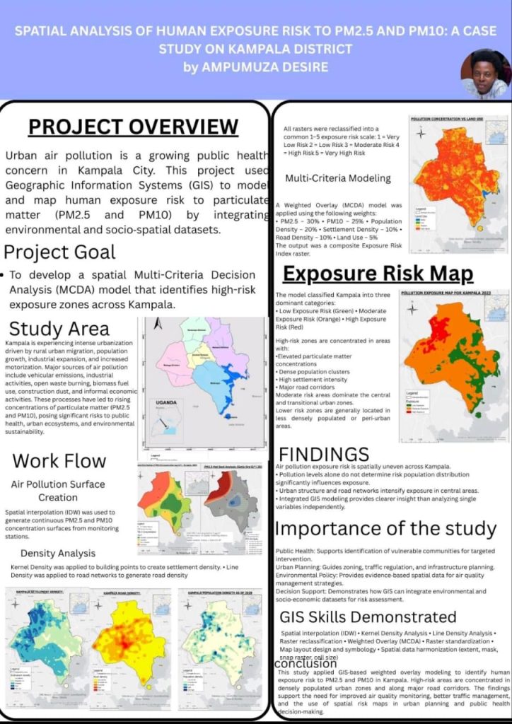
As part of her internship at Esri Eastern Africa, Ampumuza developed an interactive project focused on mapping air pollution in Kampala.
Using ArcGIS Pro, she analysed particulate matter (PM2.5 and PM10) to identify areas with high pollution levels, applying spatial techniques such as interpolation, density analysis and hotspot mapping to convert scattered measurements into continuous spatial patterns. She translated these insights into an interactive experience using ArcGIS StoryMaps, creating an experience that allows users to explore how pollution varies across the city and how factors like population density, road networks and land use influence these patterns.
By linking analysis with interactive storytelling, the project makes air pollution data more visible, accessible and easier to understand, supporting a clearer, more informed perspective on environmental and urban air quality challenges.
You can explore her StoryMap👉https://storymaps.arcgis.com/stories/e2902a38e39a4ee0b4979fc7fc1a907c and view the full project outputs👉https://experience.arcgis.com/experience/6f71927083eb4d4e91c8d6e0256df846
A Perspective Worth Carrying Forward
By the end of her experience, something had fundamentally changed. GIS became more than a technical skill for Ampumuza. It became a way of understanding patterns, relationships, and spatial context.
As environmental and urban challenges continue to evolve, this way of thinking will remain essential—not just for analysis, but for making sense of complex, real-world issues.
For Future Interns
If you’re considering the GIS Internship at Esri Eastern Africa, Ampumuza’s advice is simple: make deliberate use of your time. The experience offers more than technical exposure—it’s an opportunity to learn, explore and grow through practice.
Because sometimes, the most powerful thing you can do is make the invisible visible.
Interested in joining the Esri Eastern Africa internship program? Send your CV to careers@esriea.com and keep an eye on our social channels for upcoming opportunities and intern stories like this one.