What’s New in ArcGIS Drone2Map 2025.2
November 24, 2025 2025-11-28 11:44
What’s New in ArcGIS Drone2Map 2025.2
The 2025.2 release of ArcGIS Drone2Map introduces a robust set of upgrades designed to streamline workflows, enhance 3D realism, and improve overall processing efficiency. Below is a quick tour of the standout additions. For the complete list, be sure to explore the official help documentation.
More Realistic 3D Views with Gaussian Splat Layers
Drone2Map now includes support for Gaussian Splats—a next-generation 3D layer that captures fine detail with impressive realism. This enhancement benefits a wide range of sectors:
- Utility and telecom teams get clearer visibility of cables, lines, and components.
- Transport agencies can perform more lifelike inspections of roads, rail, and bridges.
- Environmental teams can distinguish vegetation patterns and subtle terrain variations.
- Planners and architects can present dynamic, immersive cityscapes ideal for public engagement.
Gaussian Splats dramatically elevate the visual quality of 3D scenes, enabling deeper spatial understanding across industries.
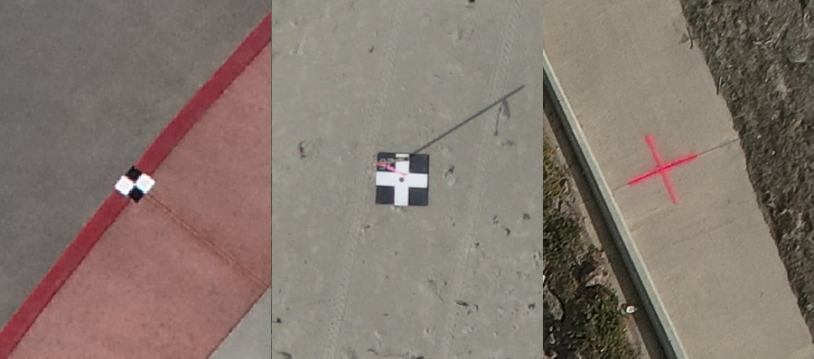
Automated Control Point Detection and Linking
Deep learning capabilities have been integrated to automatically detect supported ground control point (GCP) markers directly from imagery. Drone2Map now identifies, matches, and links these points across overlapping photos, removing the need for manual linking.
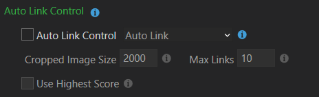
You can choose between two modes:
- Auto Link: Creates links across images for later review.
- Auto Link and Adjust: Links and immediately incorporates the points into adjustment processing.
This automation is especially valuable for large-scale projects that demand high precision under tight timelines.
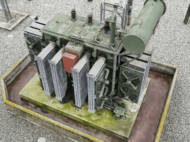
Improved True Ortho Completeness
True Ortho generation has been strengthened to deliver fuller, more reliable coverage in complex areas such as dense tree canopy or flat, featureless zones. These refinements greatly reduce missing patches and artifacts, resulting in clearer, more dependable orthomosaics for analysis and reporting.
Streamlined Workflows with VRT (Virtual Raster Tile) Support
Drone2Map can now produce virtual raster tile (.vrt) files alongside standard raster tiles. A VRT acts as a lightweight mosaic reference file, combining multiple tiles into a seamless visual layer without building a large merged raster.
This boosts:
- Performance on large projects
- Compatibility across ArcGIS and third-party platforms
- Efficiency by eliminating the need for heavy TIFF outputs
One-Click Publishing of Complete 3D Scenes
Publishing 3D content is now easier than ever. Drone2Map allows you to push full 3D scenes—including meshes, point clouds, and other layers—straight to ArcGIS Online or ArcGIS Enterprise with a single action. This removes the former requirement of uploading layers individually and assembling them in the web environment.
Automatic Application of RTK Accuracy Metadata
For imagery with embedded RTK/GNSS accuracy values, Drone2Map now reads and applies these metrics automatically. Supported tags include:
- rtk_std_lon
- rtk_std_lat
- rtk_std_hgt
- GPSXYAccuracy
- GPSZAccuracy
This ensures appropriate accuracy settings are used from the start, while also flagging images with questionable or missing metadata. Users can update inaccuracies through the Set GPS Source window.
Enhanced Mesh Editing with 3D Correction Tools
Mesh editing tools have been expanded to support direct in-app correction of 3D geometry. Users can repair holes, fix vertical faces, and resolve common artifacts caused by poor overlap or reflectivity resulting in cleaner, more polished 3D mesh deliverables.
Selective Tile Reprocessing for Faster Updates
Drone2Map now intelligently reprocesses only the individual tiles affected by edits such as waterbody masking or mesh corrections. This targeted approach reduces processing time and storage requirements while allowing rapid refinement of project outputs like DSMs, point clouds, and true orthos.
For more detailed information, browse the help documentation and join the Esri Community group to stay informed about what’s coming next.
Ready to experience the full power of ArcGIS Drone2Map 2025.2?
Explore the new features for yourself and take your drone mapping workflows to the next level. Visit our Esri Eastern Africa Online Store today to purchase ArcGIS Drone2Map and access the latest tools designed to enhance accuracy, speed, and 3D visualization in your projects.
Start your upgrade journey now your next great map begins here.