Nairobi: How Spatial Data and Maps Are Empowering Advocacy for the Urban Poor
September 28, 2026 2026-09-28 12:30
Nairobi: How Spatial Data and Maps Are Empowering Advocacy for the Urban Poor
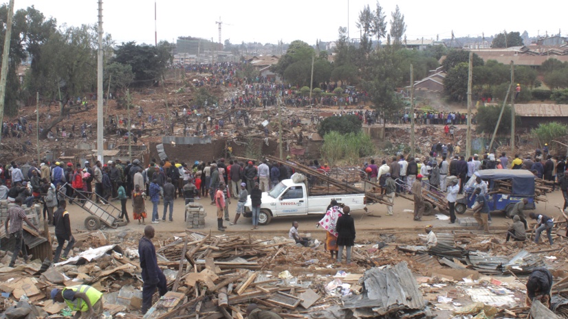
In Nairobi’s informal settlements, access to reliable information can make the difference between being overlooked and having a voice in decisions that directly affect communities. In May 2020, during the COVID-19 lockdown, approximately 7,000 people living in the Kariobangi settlement were forcibly evicted to make way for a sewer infrastructure project. In the days that followed, demolitions destroyed homes and displaced residents, leaving many families facing an uncertain future.
The situation caught the attention of Pamoja Trust, a Kenyan advocacy organisation working with urban poor communities. Concerned that similar infrastructure projects could lead to further displacement, Pamoja Trust partnered with Cadasta, a global nonprofit focused on using technology to strengthen land and resource rights.
Together, they set out to answer an important question: How many other communities could be at risk?
Using Spatial Data to Reveal What Was at Stake
The team turned to GIS and spatial data to better understand the potential impact of planned sewer infrastructure projects across Nairobi. By analysing Nairobi’s sewerage plans and overlaying proposed demolition areas with population density data from Facebook’s Data for Good initiative and aerial imagery, they uncovered a significant risk.
The analysis identified six additional demolition sites that could potentially affect more than 70,000 people living in Nairobi’s informal settlements. The maps helped transform complex datasets into a clear picture of the people and communities that could be affected.
The Vulnerability of Nairobi’s Informal Settlements
Nairobi’s informal settlements are home to a significant proportion of the city’s population, yet many residents face limited access to basic services and secure land tenure. Without formal land rights, communities can be particularly vulnerable when large-scale infrastructure and development projects are planned. Residents may face displacement with limited opportunities to participate in planning processes or advocate for alternatives.
The Kariobangi demolitions brought these challenges into sharp focus and highlighted the importance of understanding who and what is located where before development projects move forward.
Turning Data Into a Tool for Advocacy
For Pamoja Trust and Cadasta, GIS became more than a mapping tool. It became a way to communicate the potential human impact of infrastructure development. The teams created interactive maps showing demolition zones alongside population data, making it easier for communities and decision-makers to understand the scale of the potential displacement.
The information was shared with community organisations, including Muungano wa Wanavijiji, Kenya’s urban poor federation. The maps helped communities build evidence-based advocacy campaigns, resulting in petitions to the government and contributing to a temporary halt to the sewerage plans.
The goal was not to oppose infrastructure development. Improved sewerage systems remain important for Nairobi’s growth and public health. Instead, the advocacy helped ensure that communities potentially affected by the projects were included in the conversation. This opened the door to considering more equitable approaches, including compensation, consultation, and alternative housing arrangements.
Making Communities Visible Through Data
The partnership between Pamoja Trust and Cadasta demonstrates the power of data empowerment—giving communities access to information and tools that can strengthen their ability to advocate for themselves. Spatial data can make communities that are often overlooked more visible. Maps can show not only where informal settlements are located, but also the people, businesses, homes, and livelihoods connected to those places.
When this information is brought into planning and decision-making, communities can move from simply being affected by development decisions to actively participating in them.
The Role of GIS in More Inclusive Urban Development
As African cities continue to grow, governments and development organisations face increasingly complex challenges around housing, infrastructure, land rights, and access to services. GIS can help bring these issues into clearer focus by connecting people, places, and data.
The Nairobi experience shows how spatial information can support more informed conversations about development—and how maps can become powerful tools for communities seeking to protect their homes, livelihoods, and rights.
Ultimately, smarter urban development is not only about building infrastructure. It is also about understanding the people and communities that infrastructure is intended to serve.
Disclaimer: This article was originally written by Jen Van Deusen.
Discover more about how GIS is empowering communities and driving impactful change by subscribing to our ArcHabari Newsletter.