Home
June 8, 2022 2025-02-26 11:24Home
New Training and Certification Opportunities
 Rachael Mutuli
 March 21, 2025
With ArcMap set to retire in 2026, GIS professionals must transition smoothly to ArcGIS Pro. The following instructor-led courses help…
Read More

Streamlining Field Operations with ArcGIS
Rachael Mutuli
March 13, 2025
Efficient field operations are critical for organizations managing assets, infrastructure, or remote projects. However, traditional methods of
Read More

Mapping Change: GIS Empowers Nonprofits
Rachael Mutuli
March 3, 2025
In today’s data-driven world, geographic information system (GIS) technology is revolutionizing how nonprofits tackle complex social and environmental challenges.
Read More
How ArcGIS and Autodesk Are Transforming Construction Site Inspections
Rachael Mutuli
February 28, 2025
The construction industry is evolving rapidly, and digital transformation is playing a crucial role in improving efficiency, compliance, and project…
Read More

Esri EA Announces New CEO
Rachael Mutuli
February 26, 2025
Esri Eastern Africa is pleased to announce the appointment of Samuel Kimani as its new Chief Executive Officer (CEO).
Read More
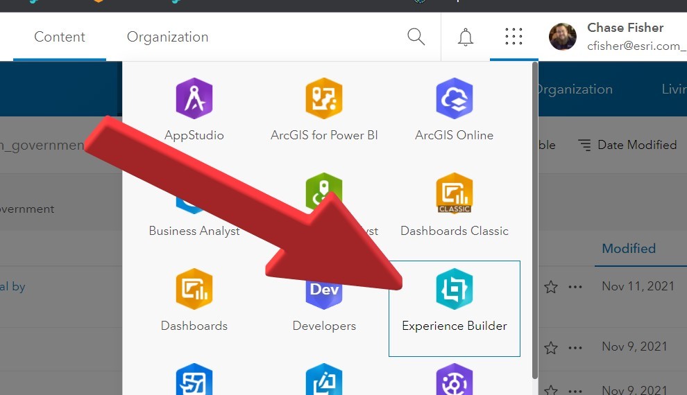
Editing Survey Responses in Experience Builder
Rachael Mutuli
February 20, 2025
Imagine being able to edit an ArcGIS Survey123 response simply by selecting a map feature. This action opens the associated…
Read More

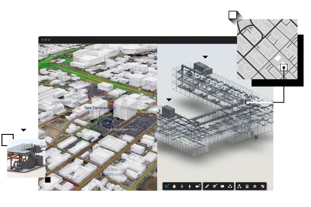
Building an Indoor GIS with Reality Capture
Rachael Mutuli
February 11, 2025
Advancements in reality capture technologies have transformed the way spatial data is collected and managed, especially in indoor environments.
Read More
What’s New in ArcGIS StoryMaps (January 2025)
Rachael Mutuli
February 9, 2025
ArcGIS StoryMaps is a powerful tool for transforming maps into engaging, place-based narratives. With its intuitive builder, you can seamlessly
Read More
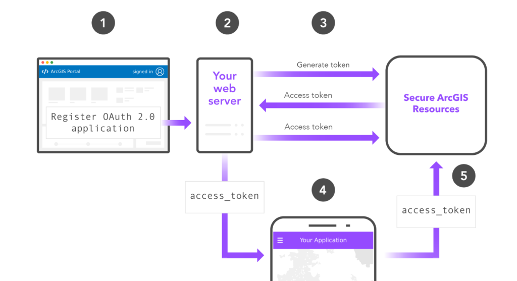
Understanding Authentication in ArcGIS Enterprise: A Guide for GIS Professionals
Rachael Mutuli
February 3, 2025
ArcGIS Enterprise is much more than a GIS and mapping platform—it’s a full-fledged enterprise IT solution. This means that, beyond…
Read More

Careers in Spatial Data Science
Rachael Mutuli
January 29, 2025
The world is generating vast amounts of spatial data, driven by advances in satellite technology, GPS, and the Internet of…
Read More
A New Era for Creating Apps
Rachael Mutuli
January 21, 2025
The future of app building is here! Esri is introducing exciting new tools—ArcGIS Experience Builder and ArcGIS Instant Apps—as ArcGIS…
Read More

Top 5 Tips for Styling Published Layers and Maps
Rachael Mutuli
January 21, 2025
Styling layers and maps can go beyond the default settings to create clearer, more intuitive designs. These quick tips will…
Read More
How to Access the Latest ArcGIS Living Atlas Content in ArcGIS Enterprise
Rachael Mutuli
January 10, 2025
The ArcGIS Living Atlas of the World offers a vast collection of ready-to-use, authoritative maps, layers, scenes, and apps for…
Read More
Seven Ways to Integrate Data with ArcGIS Online
Rachael Mutuli
January 10, 2025
To fully unlock the potential of your data in ArcGIS Online, integrating it effectively and keeping it up to date…
Read More

NASA Space Apps Challenge 2024: Sparking Innovation Across Kenya
Rachael Mutuli
December 11, 2024
The 2024 NASA Space Apps Challenge brought together coders, scientists, designers, and innovators across Kenya to tackle global and local…
Read More